A newly renovated space on the first floor of Lefrak Hall was completed on Sept. 9, three weeks ahead of schedule, said Bill Olen, interim executive director of planning and construction for Facilities Management. It’s the new home to the University of Maryland’s Geospatial Information Sciences Program.
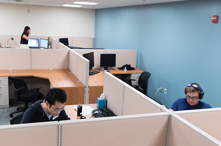
The 4,000-square-foot facility, now known as the Center for Geospatial Information Science, consists of four main components: a maker space that allows students to work on programming mobile devices; a motion capture space that allows for geospatial computing training and demonstrations; an open office space for postdoctoral researchers, graduate students and visitors; and a fourth component called the situation room, which serves as an area for seminars as well as strategic planning, said Dona Morgan, director of facilities for the behavioral and social sciences college.
“This center will enable students to perform natural observation-based research and exploration using the latest hardware and vision technologies,” Morgan said.
The space was assigned to the GIS program before the renovations, but wasn’t devoted to those specific functions, Morgan said. Before, there was only a seminar room and student study spaces.
According to Kathleen Stewart, professor and director of the center, there are currently about 260 students in the geographic information science and cartography major and about 80 students in the minor — but that figure has increased overtime, she said. Because of the increased amount of students in recent years, the behavioral and social sciences college developed a plan to create a state-of-the-art GIS center, Morgan said.
“I think the increase of students relates to students’ familiarity of GIS systems through Google Maps and cell phones,” Stewart said. “GIS is a modern twist on mapping, and students want to learn more about these technologies, especially with the increase of exciting careers in this area from local to federal government.”
The $750,000 project included removing walls, replacing the ceiling and flooring, upgrading the mechanical system — such as improving heating, air-conditioning and plumbing — and adding in new finishes to the ceiling and floor, Olen said.
The building’s furniture is currently being moved in, and most of the graduate and postdoctoral students will start their research and relocate their office space there. Stewart said over time, undergraduate research students will relocate as well.
The center will host a variety of research projects in which students can get hands-on experience in geographic information science and cartography. One of these projects is through the Center for Substance Abuse Research, where the students involved are studying the geographic patterns of heroin and other opiates in the U.S. The situation room will host courses and training workshops, some of which will start in the winter term, Stewart said.
The center also has a new master’s and graduate certificate program in geospatial intelligence that will launch next fall, Stewart said. These two programs will operate out of the Center for Geospatial Information Science.
The GIS program is planning an opening ceremony to introduce the campus to the center in the spring, once everyone and everything has been moved in, Stewart said. She added that by the end of this semester everything should be set up and in place.
“The center is a great opportunity for students to learn about GIS and gain real experience in research,” Stewart said. “We are even in the process of developing new classes and hiring another faculty member, because we know how busy the center will be.”